
America’s most stunning natural attractions draw millions of visitors who see beauty but don’t recognize the hidden dangers lurking beneath the surface. These aren’t obviously hazardous places—they’re the scenic spots that look perfectly safe, where families take vacation photos moments before conditions turn life-threatening. The same features that make these places spectacular also make them unpredictably deadly, and the transformation from peaceful to perilous can happen in seconds.
1. The Emerald Pools at Havasu Falls Turn Into Death Traps
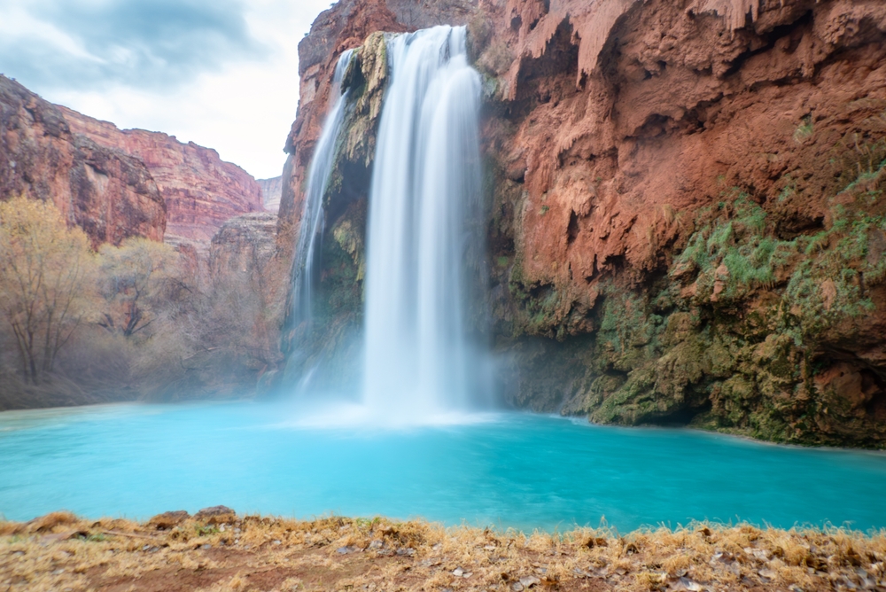
Havasu Falls’ stunning turquoise pools look like tropical paradise and attract thousands of visitors seeking the perfect swimming hole. The calm, inviting water shows no surface indication of the powerful currents and underwater hazards that have killed multiple swimmers. Flash floods can transform these serene pools into churning cauldrons of debris-filled water in minutes, with no visible warning to swimmers already in the water.
The limestone formations create underwater caves and channels with powerful suction that traps swimmers beneath the surface. What looks like a safe, shallow pool can have sudden drop-offs into underwater caverns with currents strong enough to hold people under. Flash floods in the canyon system occur even when skies are clear at the falls, triggered by storms miles upstream that visitors never see, giving zero warning before walls of water crash through the narrow canyon.
2. Yosemite’s Vernal Fall Mist Trail Granite Turns Glass-Slick Instantly
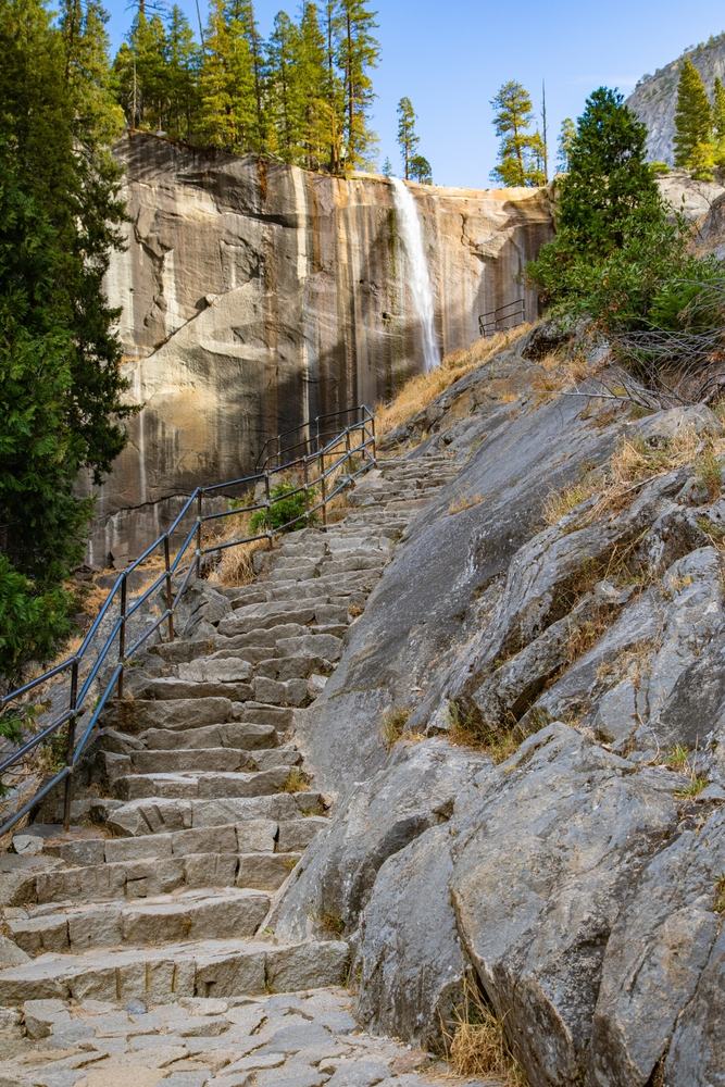
The granite steps alongside Vernal Fall create one of Yosemite’s most photographed trails, with rainbow mist and stunning views that look magical rather than dangerous. The constant mist coating the granite makes it as slippery as ice, but this isn’t obvious until you’re already on the steps with no safe way back. A dozen people have slipped on these wet rocks and been swept over the 317-foot waterfall to their deaths, often in front of horrified family members.
The danger isn’t constant—dry granite provides good traction, but mist patterns change based on wind and water flow, coating sections without warning. Hikers who successfully climbed up find the descent impossibly slippery as mist patterns shift. There’s minimal railing on sections where falls mean going over the waterfall, and exhausted hikers returning from the summit make fatal mistakes when their legs are tired and the rocks are slick.
3. Yellowstone’s Hot Springs Hide Boiling Water Under Colorful Surfaces
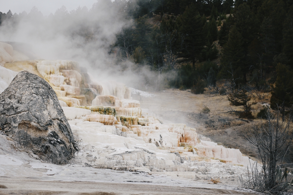
Yellowstone’s prismatic hot springs display colors so vivid they look fake, with boardwalks suggesting these thermal features are safely contained and controlled. The thin crust surrounding many springs can’t support human weight but looks identical to solid ground, collapsing without warning to plunge people into water hot enough to dissolve human tissue. Over 20 people have died in Yellowstone’s thermal features, many from stepping just inches off designated paths onto ground that looked safe.
The springs’ beautiful colors come from thermophilic bacteria thriving in water that’s literally boiling—temperatures exceeding 200°F that cause fatal burns on contact. Mist and steam can obscure the edges of thermal features, making it impossible to see where solid ground ends and boiling water begins. Weather conditions affect visibility dramatically, with foggy or misty days hiding dangers that are obvious in clear conditions, and tourists stepping off paths for photos have fallen through thin crust into water that killed them before rescue was possible.
4. The Narrows in Zion Transforms From Ankle-Deep to Wall of Death
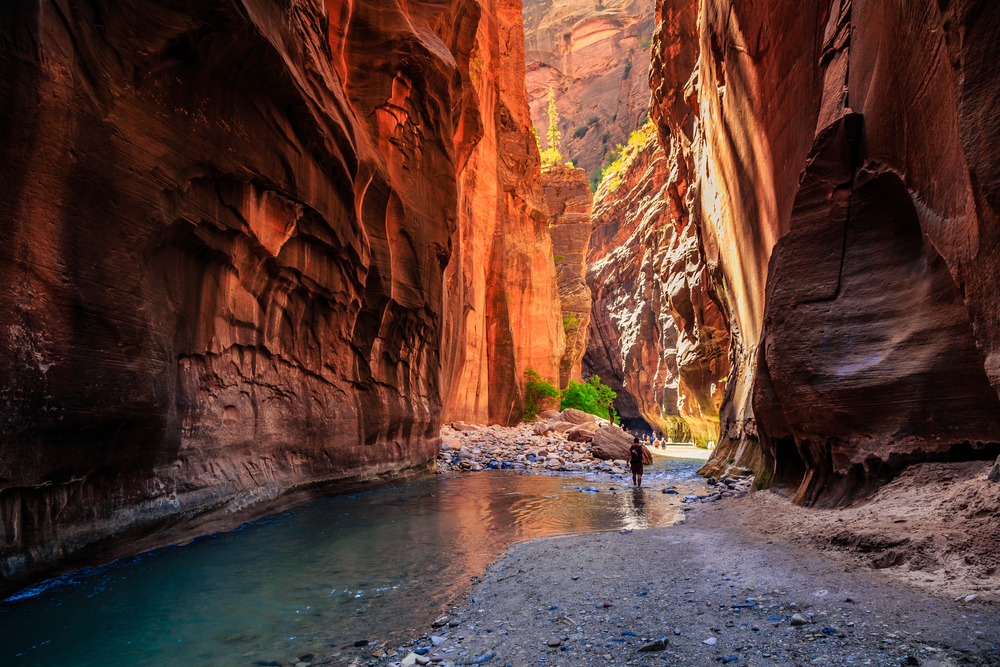
The Narrows looks like a gentle wade through a scenic canyon, with ankle to knee-deep water and families happily splashing through. The slot canyon’s beauty masks the fact that flash floods turn this peaceful stream into a 10-foot wall of debris-filled water in minutes. These floods can occur even when skies are clear in the canyon, triggered by thunderstorms miles away in the watershed that hikers never see or hear.
The narrow canyon walls provide zero escape routes—when water rises, there’s nowhere to go, and the current is powerful enough to smash people against rocks and sweep them away. Multiple drownings occur here when hikers ignore weather warnings or don’t understand that distant rain creates local floods. The water can rise from ankle-deep to chest-deep in under five minutes, transforming a leisurely walk into a desperate survival situation where the canyon walls that made the hike beautiful become a deadly trap.
5. Grand Canyon’s Rim Edges Crumble Without Warning
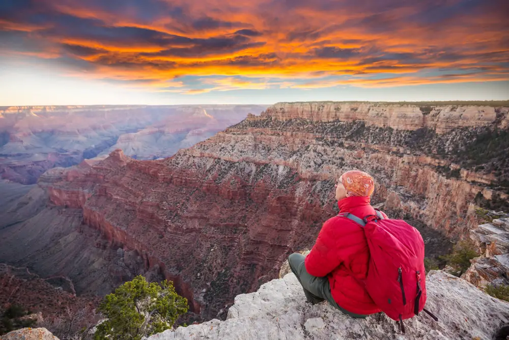
The Grand Canyon’s rim provides spectacular views from edges that look solid but are actually crumbling constantly due to erosion. Visitors step off designated paths onto rock that appears stable but can break away without warning, sending people plummeting hundreds of feet. Multiple deaths occur annually from people posing for photos too close to edges, standing on outcrops that collapse, or backing up for better angles onto unstable ground.
The limestone and sandstone layers erode at different rates, creating overhangs and edges that appear solid but have no support underneath. Morning and evening light hides shadows that would reveal how far outcrops extend past stable ground, making dangerous positions look safe. Weather changes cause rock to expand and contract, weakening edges that were stable hours earlier, and there’s no way to predict which outcrops will hold and which will crumble.
6. Lake Michigan’s Rip Currents Appear as Calm Water
Lake Michigan looks deceptively safe compared to ocean beaches, with many visitors treating it like a large swimming pool rather than a body of water that kills dozens annually. The lake’s powerful rip currents are invisible from shore, appearing as calm patches of water that actually indicate strong currents pulling swimmers away from safety. Unlike ocean rip currents, lake currents can change direction rapidly based on wind shifts, trapping swimmers who thought they were swimming parallel to shore.
The lake’s temperature—often 50-60°F even in summer—causes rapid hypothermia that impairs swimming ability within minutes. Waves come in sets that appear manageable, then suddenly increase in size without warning as wind patterns shift. Swimmers get caught in currents that pull them into deep, cold water where they can’t touch bottom, and panic sets in as shore gets farther away despite swimming efforts.
7. Angels Landing’s Final Chain Section in High Winds
Angels Landing’s approach seems manageable, leading hikers to continue to the chain section without realizing how exposed and dangerous the final half-mile becomes. The narrow ridge with thousand-foot drops on both sides offers no protection from wind gusts that can exceed 60 mph without warning. These winds are strong enough to blow people off the ridge, and they can appear suddenly as weather systems move through the canyon.
The chains provide handholds but don’t prevent falls—exhausted hikers must pull themselves up steep sections while wind buffets them from different directions. Weather conditions at Scout Lookout, where the chains begin, don’t predict conditions on the exposed ridge five minutes later. People have been blown off or lost their grip on chains when wind gusts hit, and others have frozen in terror, unable to continue forward or retreat safely.
8. Joshua Tree’s Flash Floods in Desert Washes
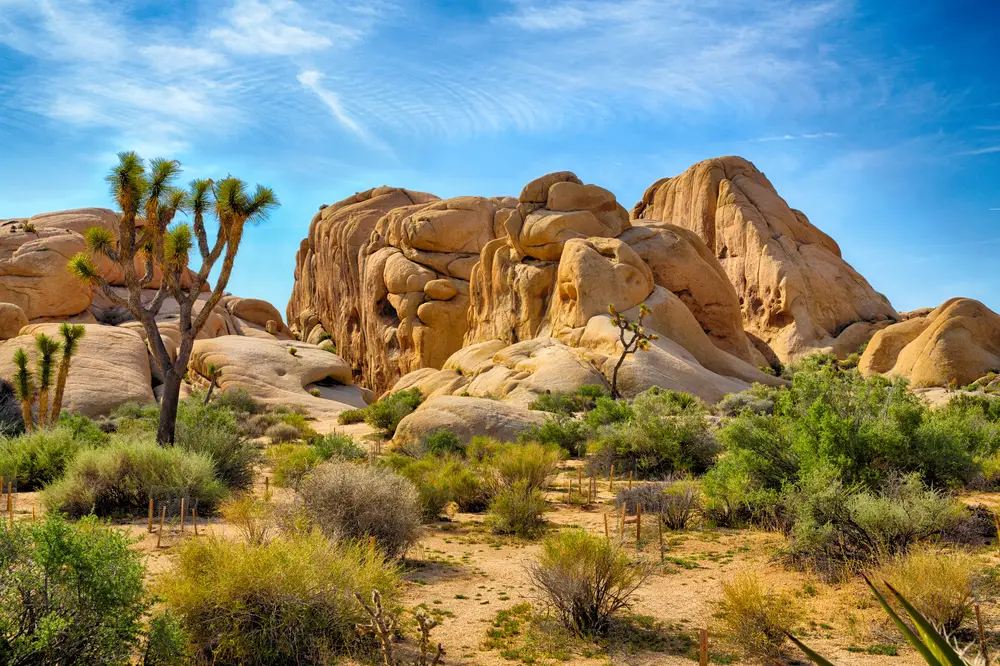
Joshua Tree’s desert landscape looks permanently dry, with sandy washes that appear to be hiking trails rather than flood channels. Desert storms dump massive amounts of water in minutes, sending flash floods through washes with no warning to hikers miles away from the storm. These floods carry boulders, debris, and enough force to sweep vehicles away, appearing as walls of muddy water in landscapes that were bone-dry moments earlier.
The desert’s hard-packed soil doesn’t absorb water, meaning all rainfall runs directly into low points and washes. Storms can occur miles away with hikers seeing clear skies overhead, giving no indication of danger before water arrives. The flat terrain makes it difficult to escape rising water, and the speed of desert floods—often moving faster than people can run—turns peaceful washes into death traps with almost no warning time.
9. Acadia’s Thunder Hole During Storm Surge
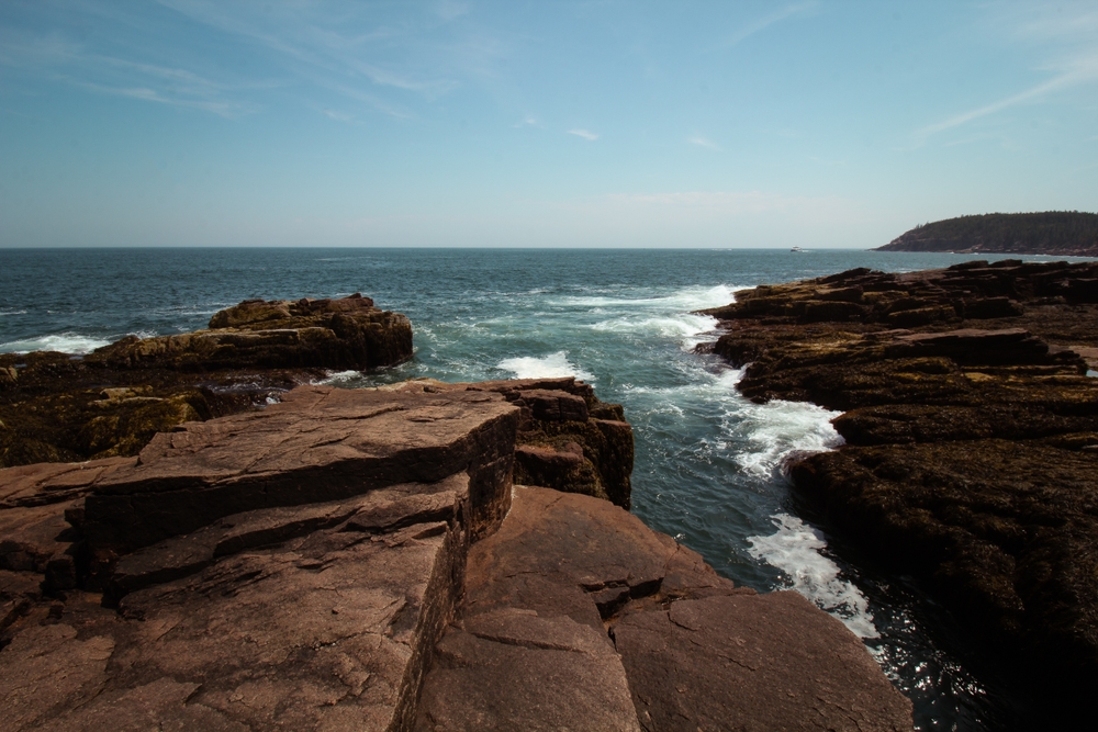
Thunder Hole on Maine’s coast looks like a safe viewing area with walkways and designated viewing spots, suggesting controlled access to natural beauty. During storms or high tides, waves can surge unexpectedly over the viewing area, sweeping people off rocks and into the ocean with no warning. The “thunder” that gives the feature its name comes from waves forcing air through a small cavern, and these same waves can reach 30-40 feet during storms.
Visitors watching from what seems like a safe distance can be hit by waves that crash higher than expected, and the rocks become slippery with seaweed and spray. Rogue waves appear randomly among smaller waves, giving no warning before suddenly surging over barriers. People have been swept into the ocean from viewing areas, and the cold Atlantic water causes rapid hypothermia even in summer, making rescue difficult even when it happens quickly.
10. Glacier National Park’s Going-to-the-Sun Road Weather Changes
Going-to-the-Sun Road climbs to over 6,600 feet with stunning views but no guardrails in many sections, and weather conditions can change from clear to whiteout in minutes. Snow squalls appear suddenly even in July and August, reducing visibility to zero and coating the road with ice. Drivers who were enjoying scenic views moments earlier find themselves in blizzard conditions on a narrow road with thousand-foot drops and nowhere to safely stop.
The elevation change means conditions at the bottom don’t predict conditions at the top—you can start in sunshine and drive into dangerous storms within miles. Wind gusts can push vehicles toward cliff edges, and ice forms on shaded corners while sunny sections remain dry. The park rangers close the road during extreme conditions, but weather can deteriorate faster than closures can be implemented, trapping drivers in dangerous conditions.
11. The Wave in Arizona’s Coyote Buttes Becomes an Oven
The Wave’s stunning sandstone formations photograph beautifully and look like a moderate hike on a map, but the exposed terrain offers zero shade in temperatures that regularly exceed 110°F. The approach involves navigating unmarked terrain using photos and GPS, and people regularly get lost in the featureless landscape where landmarks look identical. Heat exhaustion and dehydration set in rapidly, impairing judgment and making people more lost even with GPS devices.
The sandstone reflects and radiates heat, making the actual temperature feel 10-15 degrees hotter than recorded air temperature. There’s no water anywhere on the route, and the 6-mile round trip in extreme heat requires carrying more water than most people pack. Rescues of dehydrated, disoriented hikers occur regularly, and the permit system that limits visitors creates a false sense that authorities are ensuring safety when actually you’re on your own in deadly heat.
12. Pictured Rocks’ Cliff Edges Collapse Into Lake Superior
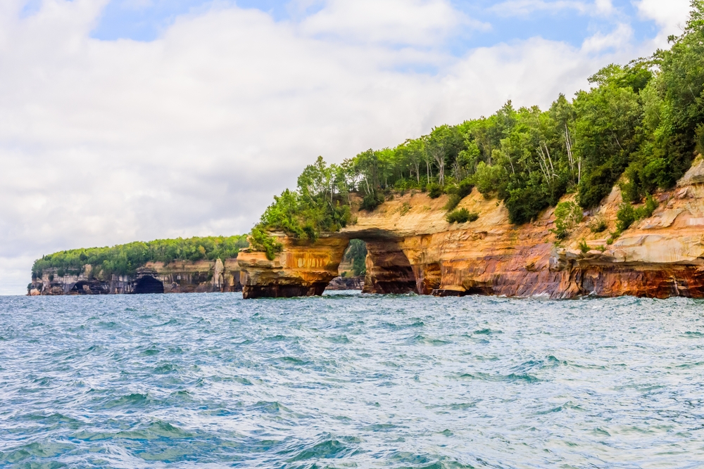
Michigan’s Pictured Rocks National Lakeshore features stunning sandstone cliffs that look solid but actively erode into Lake Superior. The colorful cliffs draw kayakers and boaters who paddle close to photograph the formations, not realizing that rock falls happen without warning. Large sections of cliff face collapse regularly, sometimes triggered by nothing more than water erosion or freeze-thaw cycles, sending tons of rock into the water below.
Hikers on trails atop the cliffs walk near edges that can give way suddenly, with no indication which sections are stable and which are ready to collapse. The 200-foot cliffs mean falls are unsurvivable, and the cold Lake Superior water causes hypothermia in minutes even for survivors. Recent collapses have killed kayakers paddling beneath seemingly stable rock that chose that moment to fall, demonstrating that these aren’t rare events but ongoing erosion that’s completely unpredictable.
13. Arches National Park’s Delicate Arch Area in Lightning Storms

Delicate Arch sits in completely exposed terrain with no shelter, and afternoon thunderstorms arrive suddenly with lightning that strikes the highest points—which includes hikers on the slickrock. The iconic arch attracts hundreds of hikers daily who time their arrival for sunset, exactly when thunderstorms are most likely. Lightning strikes on the exposed rock give no warning and no safe response—you’re the highest point for miles with nowhere to shelter.
The approach crosses exposed slickrock that becomes treacherously slippery when wet, turning the descent into a sliding hazard with poor footing. Storms can appear over the horizon and arrive at the arch within 10-15 minutes, not enough time to safely descend. Hikers who wait out storms at the arch are standing in the most dangerous possible location, while those who try to descend face slippery rock and continued lightning exposure.
14. Mount Rainier’s Glaciers Hide Deadly Crevasses
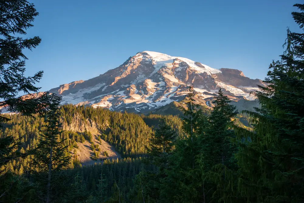
Mount Rainier’s snow-covered glaciers look like beautiful snowfields, but beneath the surface lie crevasses deep enough to kill—some over 100 feet deep and completely hidden by snow bridges. These snow bridges look solid and are often indistinguishable from safe snow, but they can collapse without warning under a person’s weight. Multiple deaths occur on Rainier when climbers or hikers fall through hidden crevasses, sometimes disappearing completely into ice chasms.
The glaciers are constantly moving and changing, meaning safe routes from previous days can be deadly today as new crevasses open and snow bridges weaken. Weather affects snow bridge strength dramatically—warm days weaken bridges that were solid in cold temperatures, and there’s no way to visually assess their stability. Even experienced mountaineers fall through unexpected crevasses, and solo hikers who fall have no one to rescue them from ice prisons that are impossible to escape without help.
15. The Blue Hole in Santa Rosa, New Mexico, Has Hidden Underwater Hazards

The Blue Hole looks like a perfect swimming spot with clear blue water in a natural sinkhole that seems safe and inviting. The 80-foot-deep hole attracts swimmers and divers who treat it like a diving pool without understanding the underwater hazards. The water temperature drops dramatically with depth, causing hypothermia even on hot days, and the underwater cave system has narrow passages that have trapped and killed divers.
The deceptively calm surface hides strong underwater currents from the artesian spring that feeds the hole, and these currents can pull swimmers down or sideways into underwater formations. Divers become disoriented in the underwater caves, and several have died after becoming trapped in narrow passages or losing their way in silty water with zero visibility. The hole’s beauty and easy access create a false sense that it’s a safe swimming spot when it’s actually killed multiple people who didn’t respect the hidden dangers beneath the inviting blue surface.